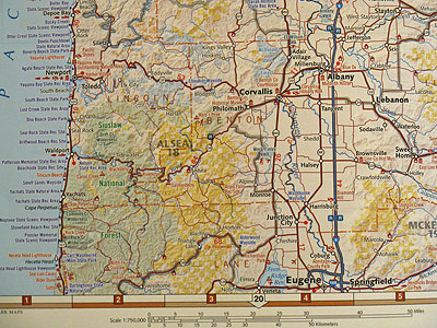
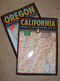
One of the tools I use to help locate potential camping spots is a Road and Recreation Atlas, from Benchmark Maps™. These atlases provide a lot of useful information for the recreational enthusiast that you don’t find on regular maps, like campgrounds, unimproved roads and trail heads. The company produces these atlases for eight western states and each state is broken down into various map scales, from 1:750,000 (1-inch equals about 12 miles on the map) to more-detailed 1:250,000 (1-inch equals 4 miles on the map) pages.

One of the features that I really like about these maps is how they use color shading to show who the managing authority of the land is. In the image above, the yellow-shaded areas are BLM land and the green-shaded area is Forest Service land. This is important to know if you are interested in dispersed camping, or camping outside of a designated campground (see Family Camping – Skip the Campground for more information.

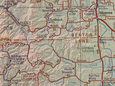
This image is a section of a 1:250,000 scale map that shows the kind of detail that you can expect from a Road and Recreation Atlas. For this particular trip, we were headed to the Alsea Falls BLM campground shown in the top-left corner. This small campground does not accept reservations, so you would not find it listed on the Reserve America or Reservation.gov sites, or even Googleâ„¢ Maps. BLM roads are shown and labeled with their road numbers (Township, Range, and Section), making it easy to order a more detailed map of the area from the BLM, if required.
The maps do not have elevation contour lines, but the spot-elevations and the shading do depict a good representation of the relief. I think that Benchmark Maps was wise in choosing readability over possibly crowding the maps with contour lines. In all, I’m very happy with these atlases and, while they may not be essential for everyone, they are very useful for those of us who like to explore the backcountry.
See also…


Thanks Suzi, that’s a great resource!
Although you won’t find BLM campgrounds or National Forest developed campgrounds with less than ten campsites give US National Forest Campground Guide website (www.forestcamping.com) a look. It’s free to the public and we’ve provided 50-plus fields of information for over 2,000 campgrounds.
Argh! Being a resident of one of the most sales tax-burdened counties in California (8.25%), I’ve become quite adept at locating items sold by companies with no presence here (Benchmark Maps is in Oregon – a no sales tax state). It’s hard to find a company that will ship orders valued at less than $50, though.
Roy, once again, you’ve proven you are a helpful and very responsive resource. I’ve purchased and will review the DeLorme map when it arrives (and have a chance to test it. Drawbacks to their service, so far, are two: 1) I may not want to “create an account” with them when I already know the product I wish to purchase (/sigh, but I did). 2) The shipping and tax were an additional 50% of the map cost. That’s a bit of a shocker when you’ve already become “a web member”.
The only reason I say anything is that I’ve got $30 invested in so many items and $20 vs. $30 is big. I’m an admitted camping gear-head. Many of the gimmicks at that price point really do live out their dollar value, and many more don’t. Nevertheless, thanks again for the resource, and here’s to hoping they make bank on the sale value! 🙂
Thanks again,
-Dan
Dan’s last blog post..Stand-A-Spoon-Up Spaghetti
A couple of people have asked about similar maps for other areas of the country. DeLorme (shop.delorme.com) has an “Atlas & Gazatteer” series for each state. They’re in a 1:200,000 scale (1″ = about 3 miles), but they have contour lines instead of relief-shading. They’re not bad.
These maps look great–thanks for the resource. None for Nebraska though! They must not want to waste time adding the symbols for cornfields… \|/ Maybe I’ll look into the Colorado one, it’s no coincidence that’s a popular state for camping. 🙂
Dan’s last blog post..Jamaican Tri-Tip and Gravy
Yep, that’s for sure. The other day someone sent me an email telling me that they were going about 48 miles on a desert 2-track(I know the road) and that they would call when they returned. Well they said they would call around 4 in the afternoon. So at 9pm I started making some phone calls to some 4×4 friends and they all came over to my house. I called this person’s cell and home and tried them on a base cb, no answer. So we all started to go and then at ten PM I got this cell phone call from a nearby casino and it was this person. She said: “I forgot to call, I’m sorry” Alls well that ends well, just remember don’t let someone know and then forget to let them know your back.
Great tip! I took a look at the examples for Idaho and was able to see accurate information on areas that I’m familiar with. I’ve bookmarked the website and will take a look at it again before our trip out west next summer.
Brent – your tip on letting people know where you are going to be is a good one. I’ve been stranded twice out in the boonies when I got stuck a beaver bog in my four-wheel drive SUV.
Mike Goad’s last blog post..Another Road into the Tetons
Don’t get the wrong idea: buy these maps and you’ll be safe four wheelin’. It’s never a good idea to go alone, with one vehicle. I have plenty of times, but now I’m realizing I shouldn’t. And always let someone in your family or a close friend know when you are going, if something does happen like a vehicle break-down and you don’t call them on your return, they could call for help. I also suggest if you do go on backroads you invest in a cb radio. Channel 9 is an emergency channel and it’s monitored 24/7 should something ever happen. Its just a good idea to be prepared as possible. The maps are great I own seven of them!
I love maps. I had a lot of older forest service maps from the 30s and 40s. Did you know they moved campgrounds and roads? Did you know later forest service maps actually hid campgrounds and roads that were still there? Not big campgrounds but older obscure ones they didn’t want used much. Weird. We used to find them and look for old beer cans back when I was collecting them.
VE’s last blog post..VE’s Cutting Edge Fashion Trends for 2009